Key Locations For Targeting Bass
Have you ever wondered where the best places to start fishing are?
Have you ever been stumped about where all the fish are hiding?
Were there times when you can’t seem to locate any fish?
I watch the professional angling scene quite a bit and I’ve always wondered how these guys know exactly where to find fish. I mean, I hit the lake and I’m casting at every rock, tree and boulder I can find and…nothing. I’m sure some of you have been there before and it hurts when you go a whole day of fishing with nothing to show for. Well, here’s something I learned that can help you locate bass even before you step foot on the lake. I’ll be showing you how to use Google Earth to find key locations that will help you increase your chances of catching fish before you even step foot on the lake.
WHAT IS GOOGLE EARTH
Many of you are probably familiar with Google Earth as an excellent mapping guide for travelers. For those of you who don’t know what Google Earth is, it’s a free program that allows you to see aerial images taken from satellite. So, how does this help you find more fish? As the water level recedes from seasonal draw down, more of the lakes terrain is exposed. So over a period of time, Google Earth is able to capture the lake at various states when the water levels were higher or lower. Here is where Google Earth shines. If Google Earth happened to capture an image of the lake when it was really low (like during California’s worst drought in history) you can go back in time and mark each and every location that can hold bass. This is a great way to locate fish when the water levels are at their normal capacity or higher. Below I’ll show you exactly how to do that and where to look for them.
GOOGLE EARTH PREFERENCES
First of all, here’s the link to download Google Earth. It’s completely free!
Before we begin, these are some preferences that work for me. If you go to Tools->Options. In the 3D View tab, you want to use Decimal Degrees. Having the units in decimal degrees, in my opinion, makes it easier to copy over to your GPS Navigation System or Handheld GPS device when you create a placemarker (I’ll go over what placemarkers are later). In the Navigation Tab, you want to have selected Do not automatically tilt while zooming. This will stop Google Earth from tilting when you zoom in to look at potential fishing locations.
LET’S GET STARTED
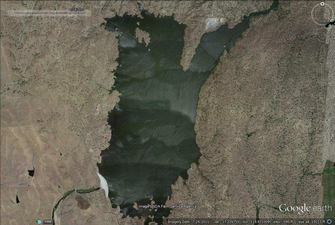
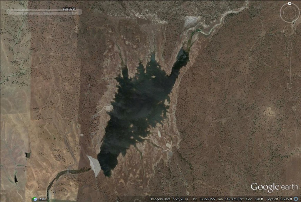
I’ll be using one of my favorite lakes: Eastman Lake, in identifying potential locations to fish. You can apply this same concept to your local lakes, reservoirs, ponds, estuaries or river systems. In the search box, type in H. V. Eastman lake, CA, click enter and Google Earth will take you to the lake. In the top image you can see the lake at full capacity. Just below that is the lake level taken on 05-25-14, which is the lowest level shown in Google Earth since the writing of this article.
So is there a bright side to having the water level this low? Of course! You can see all the structure and cover the fish can relate to. In addition to the lake structure, you’ll see a detailed map of the terrain in and around it as well. Now here’s where Google Earth is so powerful. If you’re lake happens to be a lake that gets drawn down on a seasonal basis, you’re in luck. Eastman Lake happens to be one of those lakes. Every spring, the snow melt fills the lake and every summer, the Army Corp of Engineers draws down water for farming irrigation. Google Earth has a feature called historical imagery. You can find the icon near the top of the software. It’s the one that looks like a clock with an arrow going in a counter clockwise manner. I’ve identified this for you below.

It allows you to view images taken from previous years. Click on the back arrow a few times and you’ll see the lake level increase or decrease from image to image. Go ahead, take a minute and try it out…I can wait. Pretty cool, huh? This feature is very useful for identifying structure and cover when the lake levels are low. If the current water level at your lake is higher than the Google Earth image, you know exactly what is underneath the water on your next trip.
So now that you know how Google Earth can help you find potential fishing locations, let’s find out what locations we need to look for.
DIFFERENCE BETWEEN STRUCTURE AND COVER
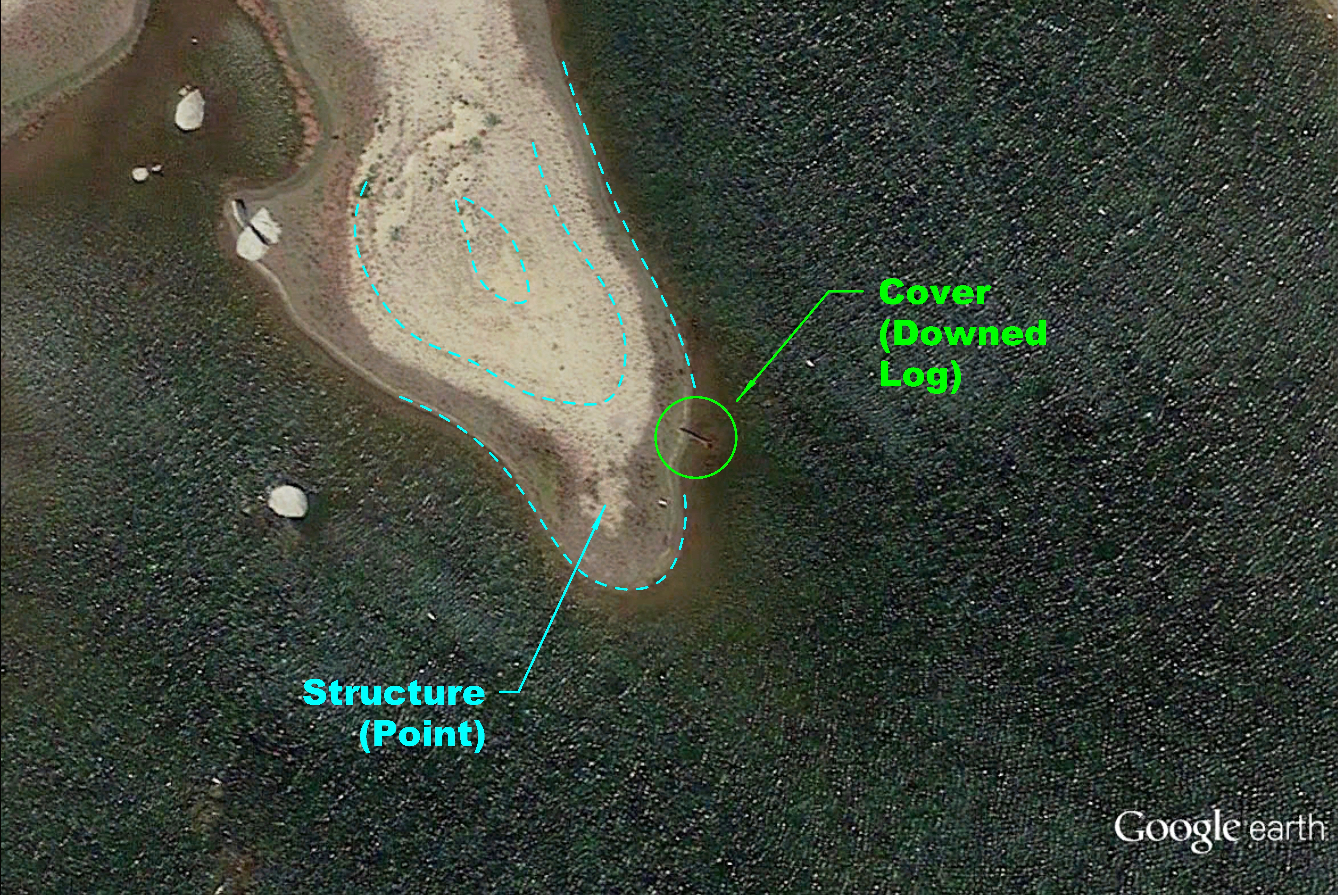
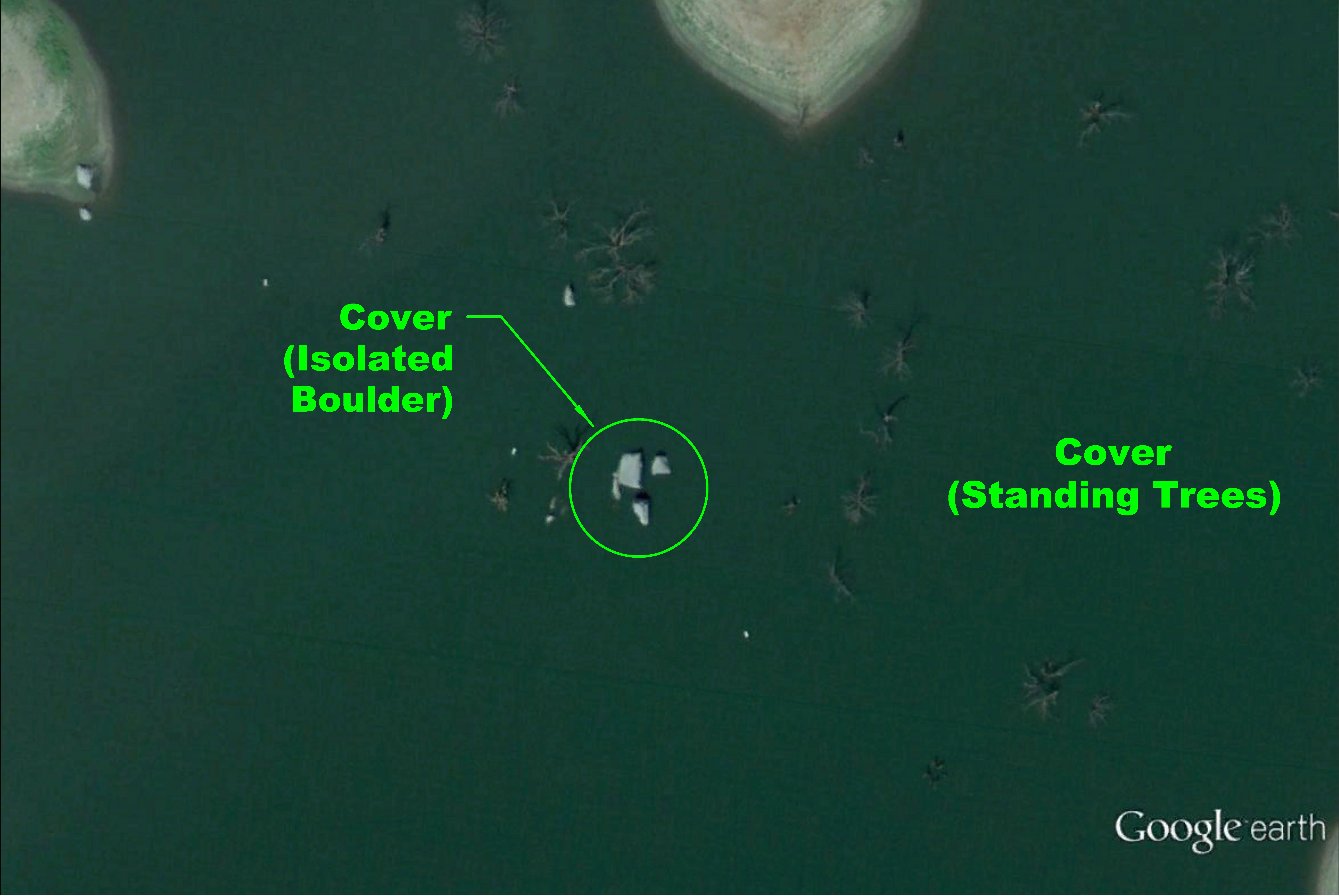
Here’s something I need to clarify before we move on. You need to know the difference between structure and cover. Don’t get the two mixed up. When I refer to structure, I mean actual terrain that forms the topology of the lake. For example, the dam is a structure. Additionally coves, water channels, submerged islands, river arms, points and many more I haven’t listed are all structure as well. I’ll be covering some of these locaitons in a bit so don’t get discouraged if you’re still unsure. Cover on the other hand is dependent on structure. So for example, we have an underwater channel with a boulder next to it. The boulder is considered cover because it does not form the landscape rather it’s an entity that’s part of the landscape. Another example of cover is a downed log submerged on the shoreline. The log is an object on the lake but the shoreline forms the topology of the lake. Here are some examples of structure and cover.
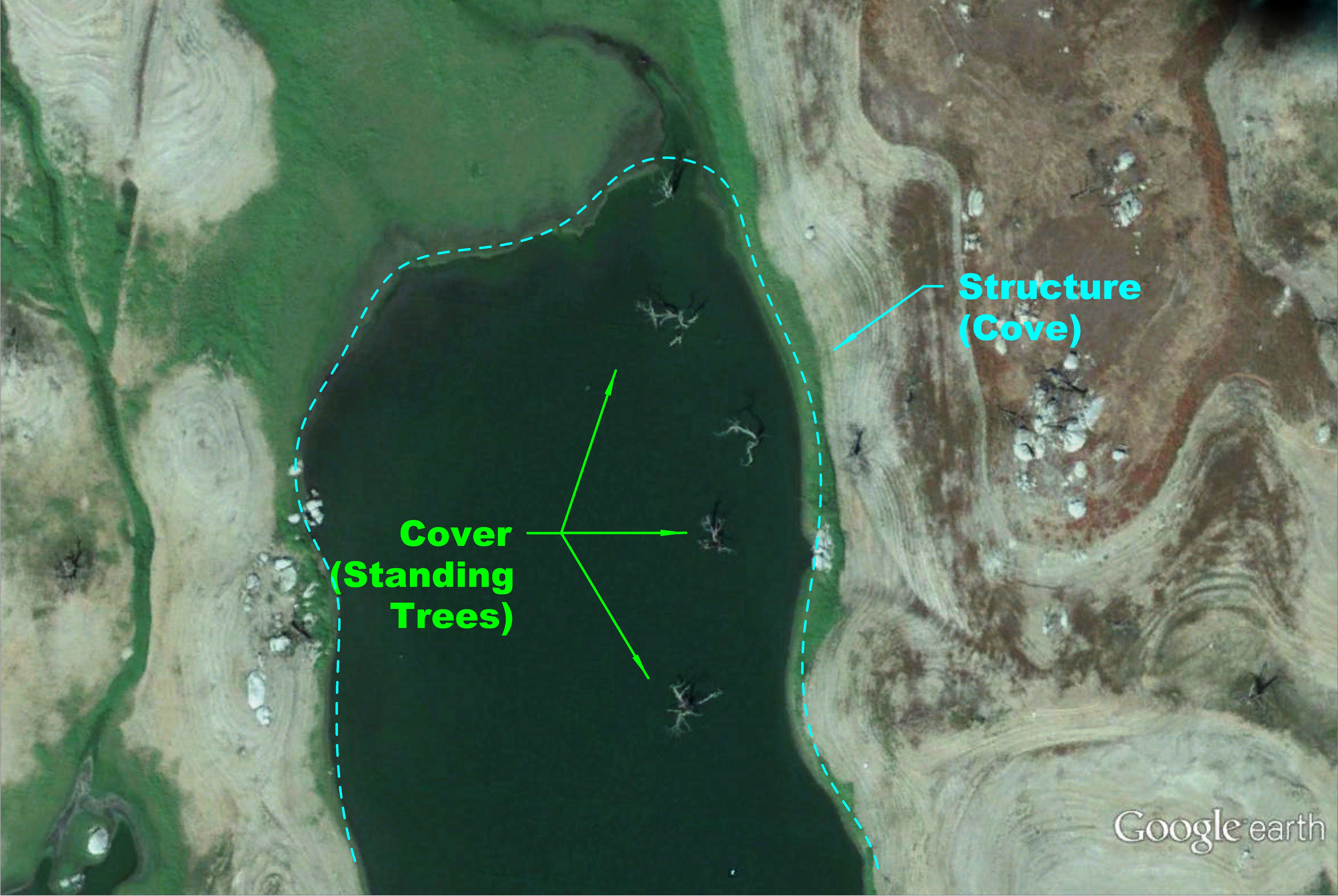
This should give you a good idea about the differences between structure and cover. Let’s move on shall we.
BEST LOCATIONS TO FISH
I have identified some potentially productive areas for bass fishing below. There are literally hundreds of other locations that hold bass as well. Here are some locations that will get you started.
POINTS
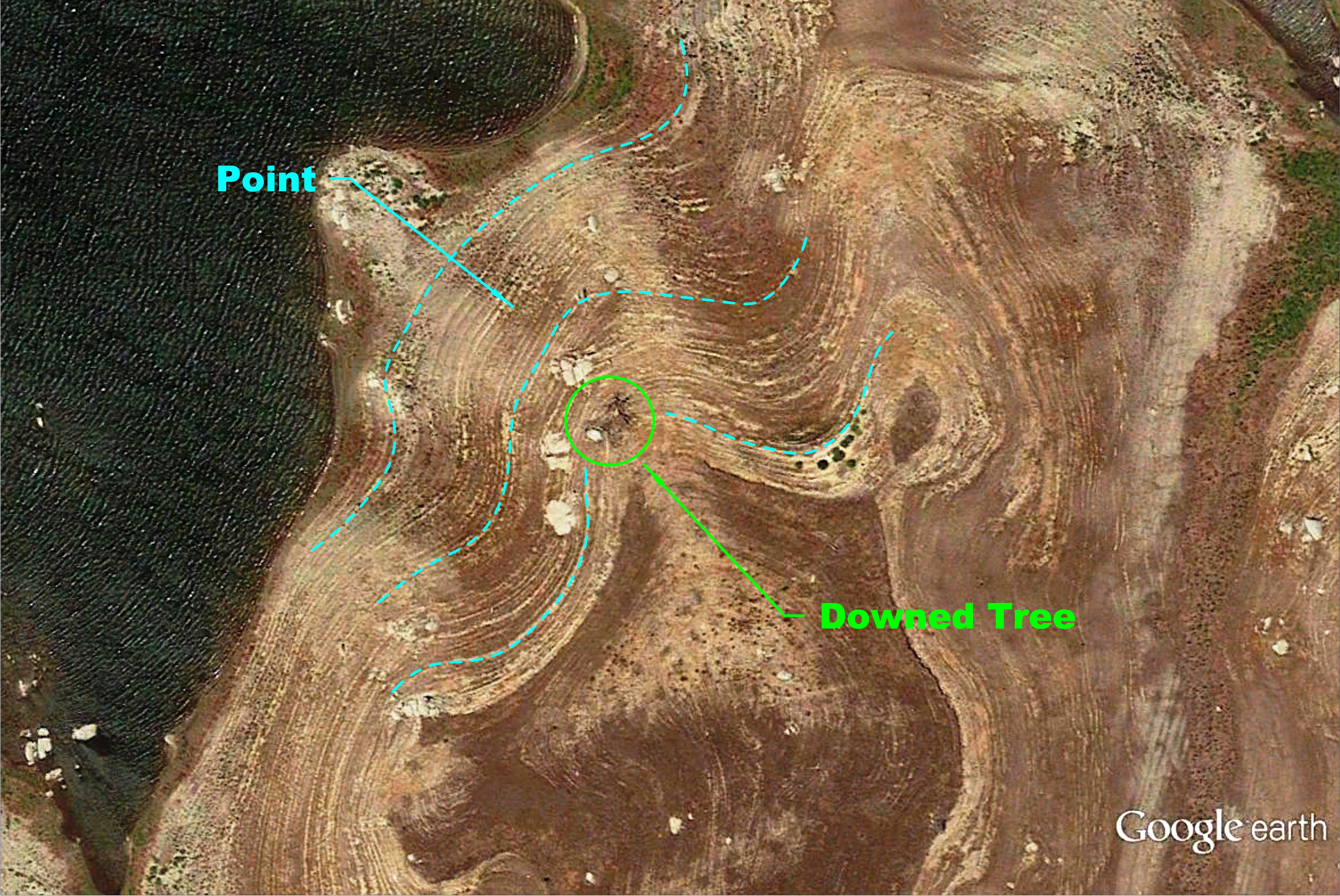
A point is part of the shoreline that protrudes out into the lake and slopes downward in elevation. Bass like to congregate here because it provides a good place to ambush prey and it has access to deeper water when the fish feels it’s in danger. To give you a better idea of how to identify these locations, I’ve found a few places using Google Earth. If you look closely at this image, you’ll see that as the water recedes, it creates these contours (ripples) along the shoreline. Keep in mind, not all points will have distinct contours. I’ve outlined a few contours in a light blue color. This point also has a downed tree that bass can use for cover.
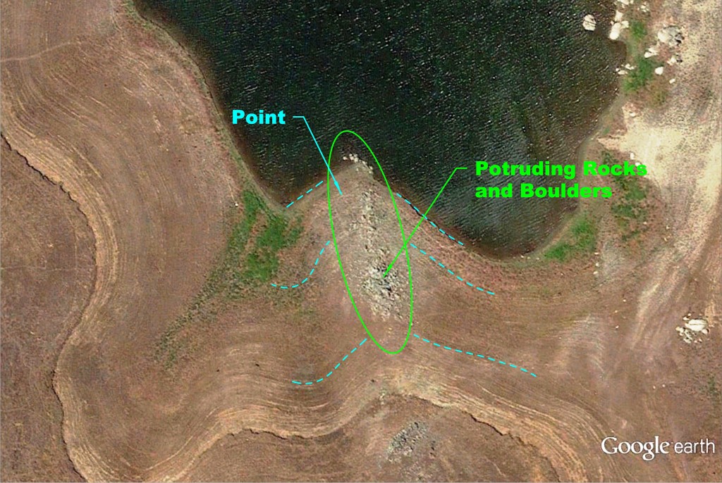
You want to find points with cover such as rocks, boulders or trees. Points that have cover can be more attractive to bass because they can hide or hunt using them. This particular point is littered with rocks and boulders. It would be a great place to start looking for fish as well. The rocks and boulders may shelter crayfish and bluegills that bass feed on.
As you can see, points can be very productive if you decide to fish them. Not all points are created equal so you will have to move from location to location to find a productive one. Using Google Earth will help narrow down potential areas when you are out on the lake.
RIP RAPS
RipRaps are usually man-made structure. The face of a dam made from rocks, boulders or concrete slabs stacked on one another is a good example of a riprap. The edges of some paved boat launches are also good examples of ripraps. Like a point, rip raps provide a good place for ambush and access to deeper water. Ripraps also provide cover for baitfish through tiny gaps and holes created by the rocks and boulders. Crayfish, minnows, bluegills and many other baitfish find refuge here. These are great forage locations for feeding bass.
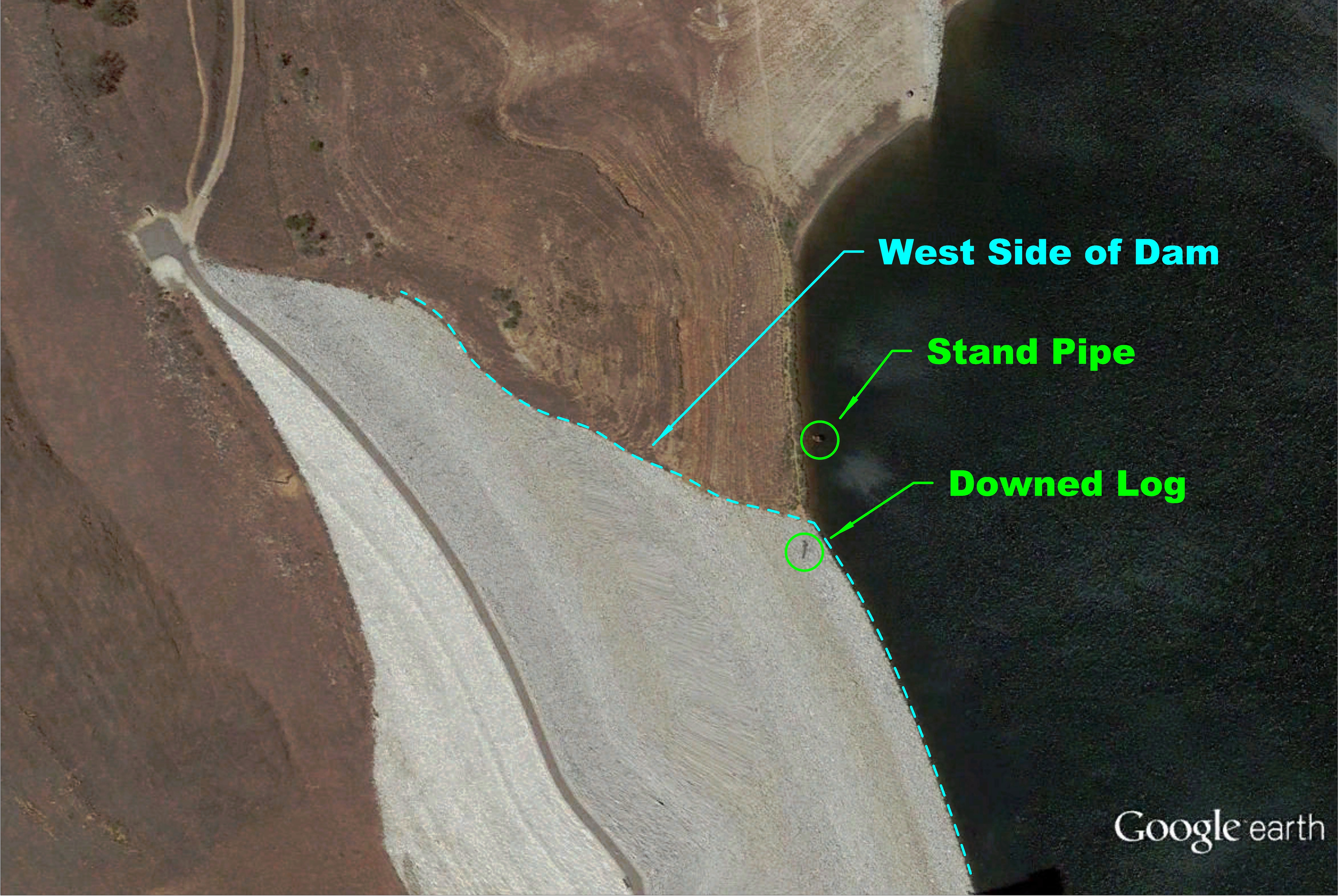
Below is an image of the west face of the dam at Eastman Lake. Using Google Earth, you can make out a downed log on the dam. This one change on the vast rocky surface can become a magnet for finding bass. There is also a stand pipe just to the west of the dam. An isolated standpipe such as this can serve as a staging point for bass before they move onto the dam to feed. Another good place to start would be where the dam meets the surrounding terrain. This change in structure will attract bass as well. So, just like that you have a reason to hit the dam before you even step foot on the lake.
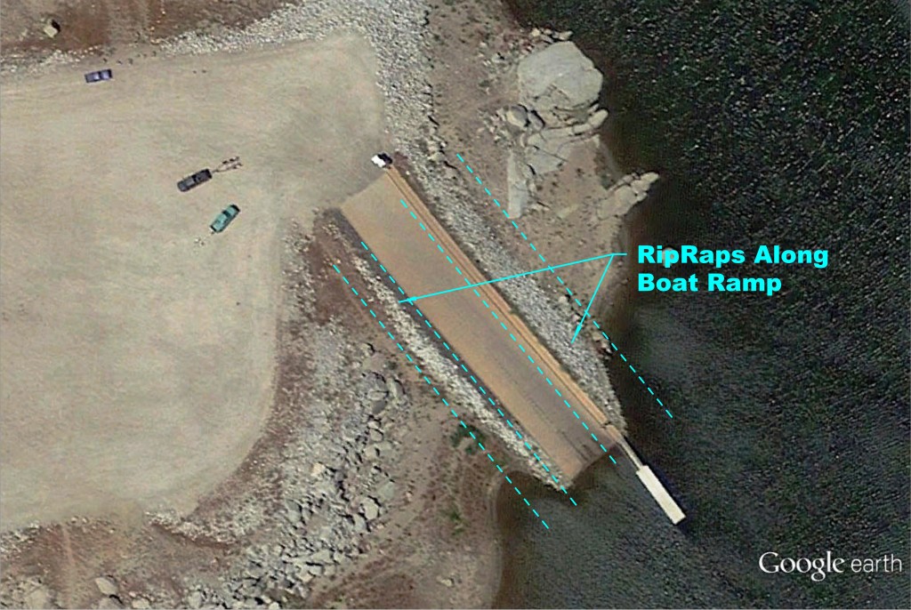
Another good location to start would be the boat launch. Many lakes that draw down water annually have multiple boat launches because the water fluctuates throughout the year. This lake has three launch ramps on the east side and two on the west side. If you happen to fish the lake when the water level is above the boat ramps, fish along the edges of the submerged boat ramp. The abrupt change in elevation from the ramp edges are magnets for bass because bait fish use this as a place to hide. If you’ve ever been to a boat launch, you’ll notice small fish sometimes congregate along these edges and on the ramp itself. It also serves as a highway for fish traveling to deeper water much like a game trail for land animals.
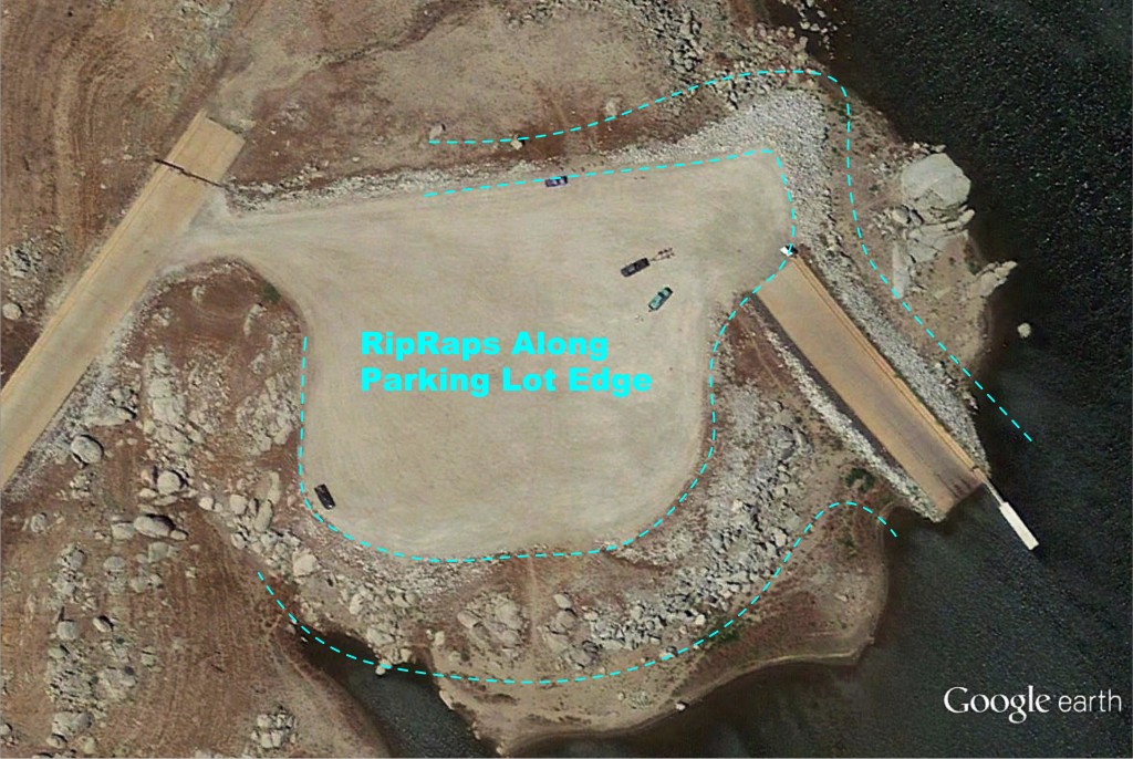
Some lakes can get so low sometimes that they’ve built temporary parking lots to accommodate the boat ramps. Not only is the ramp itself a good location for fishing, the edge of the parking lot serves as a rip rap itself. On this lake, it is surrounded by boulders and rocks, which make great cover for bass to ambush prey. Fishing along these edges can be very productive as well.
SUBMERGED ISLANDS
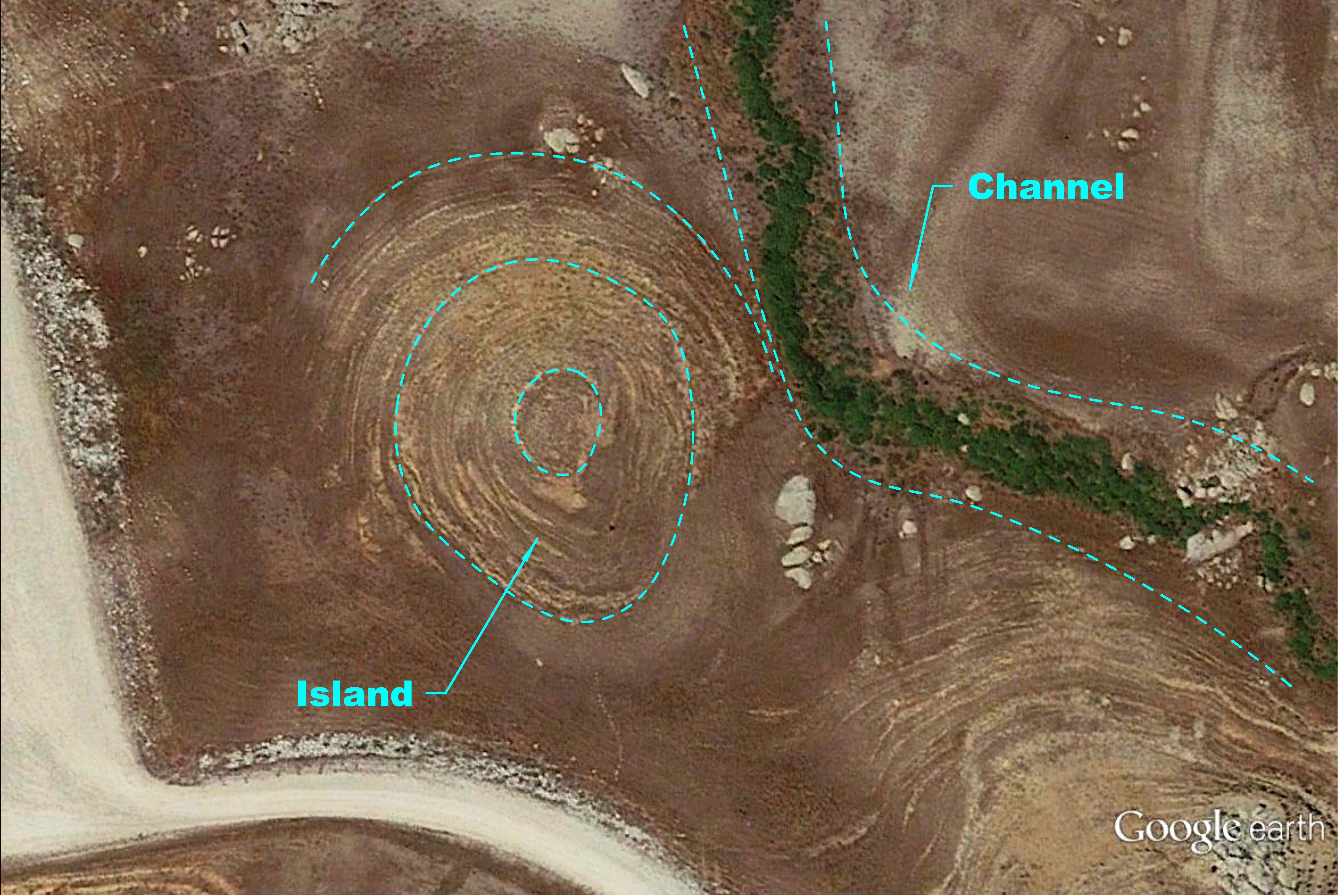
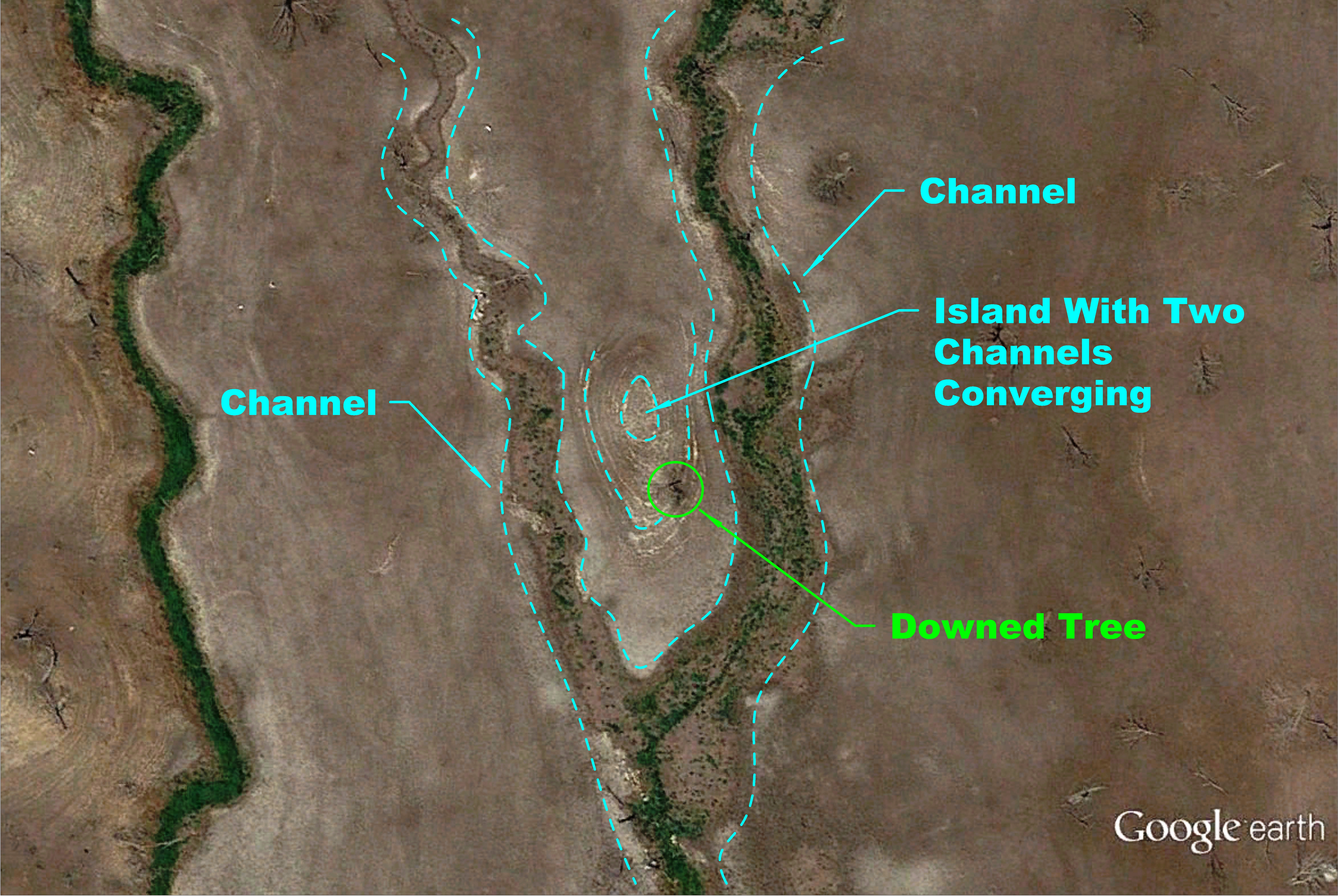
If you look at the overall map of Eastman Lake, you’ll see scattered humps throughout the compound. Depending on the lake level, these submerged islands can be anywhere from 2 feet to 30 feet under water or partially above water. If the water level at the peak of the hump is about a foot or two underwater, it can be a great place for holding bass. Look for these locations with some cover on them like rocks, boulders, downed logs or vegetation. Bass will use underwater vegetation as cover to ambush unsuspecting prey. When the islands are 15 or more feet underwater, sometimes schooling bass will congregate around the climax of the hump. These are sometimes inactive fish but if you can trigger one fish to bite, it can set off a feeding frenzy and catching multiple fish in a short period of time is certainly possible. In this image, the submerged island is actually located next to a channel. I’ll go into more detail about the significance of deep water channels in a bit. A location such as this shouldn’t be overlooked. It has access to deeper water through the channel and the hump of the submerged island provides access to shallower water. Bass that travel from deeper waters to shallower waters to feed will certainly congregate in areas such as this.
Below is a submerged island surrounded by two deep channels that run along each side. It also has a downed tree which can provide cover for both bass and baitfish. Bass may concentrate in the deeper channels during hours of inactivity but when they transition into a feeding mode, they’ll travel to shallower waters to feed. Since both sides of the deep water channels are flat areas with minimal cover, the island may attract feeding bass into that area.
I’ve identified a few submerged islands so you know what to look for when you search your own lakes. You can locate new submerged islands as the water rises or recedes using Google Earth’s historical imagery feature. As the water rises, islands that were previously above water may become new fishing ground and using Google Earth, you can pin point exactly where these submerged islands are when they’re underwater.
UNDERWATER CHANNEL
Bass often migrate to different locations throughout the day. They will travel to shallower waters to feed and use the deeper water channels as a highway for traveling to these locations. Bigger fish will relate to these deeper areas because it provides them a sense of security. If you’ve ever hooked into a larger fish before, most of the time it will head straight for deeper water. Channels happen to be the deepest part in the area. If you can find cover that the bass or bait fish can relate to, your odds of finding them will increase as well. In the image below you can see two large boulders situated next to a channel.
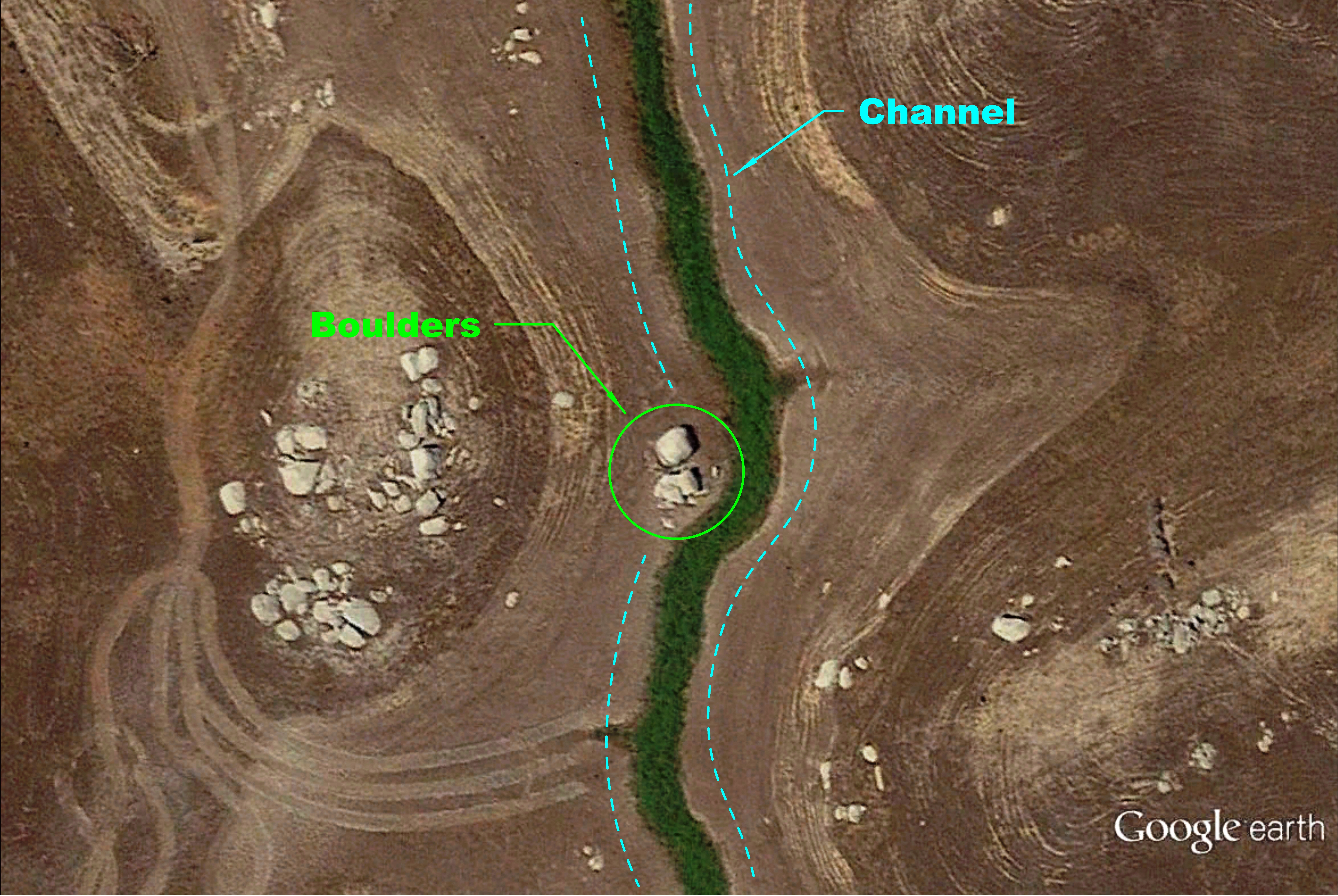
A location such as this can be a great place for targeting bass and here’s why. There are two big boulders stationed along the underwater channel that can provide cover for staging bass before they move into the shallows to feed. Plus, the boulders can be a great place for bait fish to hide in as well. To the left is a submerged island that bass can use as a feeding ground and to the right of the boulders is a small cove that can accomplish the same thing. Another added bonus to this location is the bend in the underwater channel just to the right of the two boulders. Fish will travel along these channels like a road. Using the bend to their advantage and the boulder as cover, predatory fish can ambush prey when they travel through here. Not all lakes will have this same feature but something similar will definitely increase your chances of finding them.
This particular channel has two standing trees stationed along the channel edge. Other than a submerged island located to the left of the channel and cluster of rocks at the bottom left of the image, there really isn’t much structure or cover for bass to relate to.
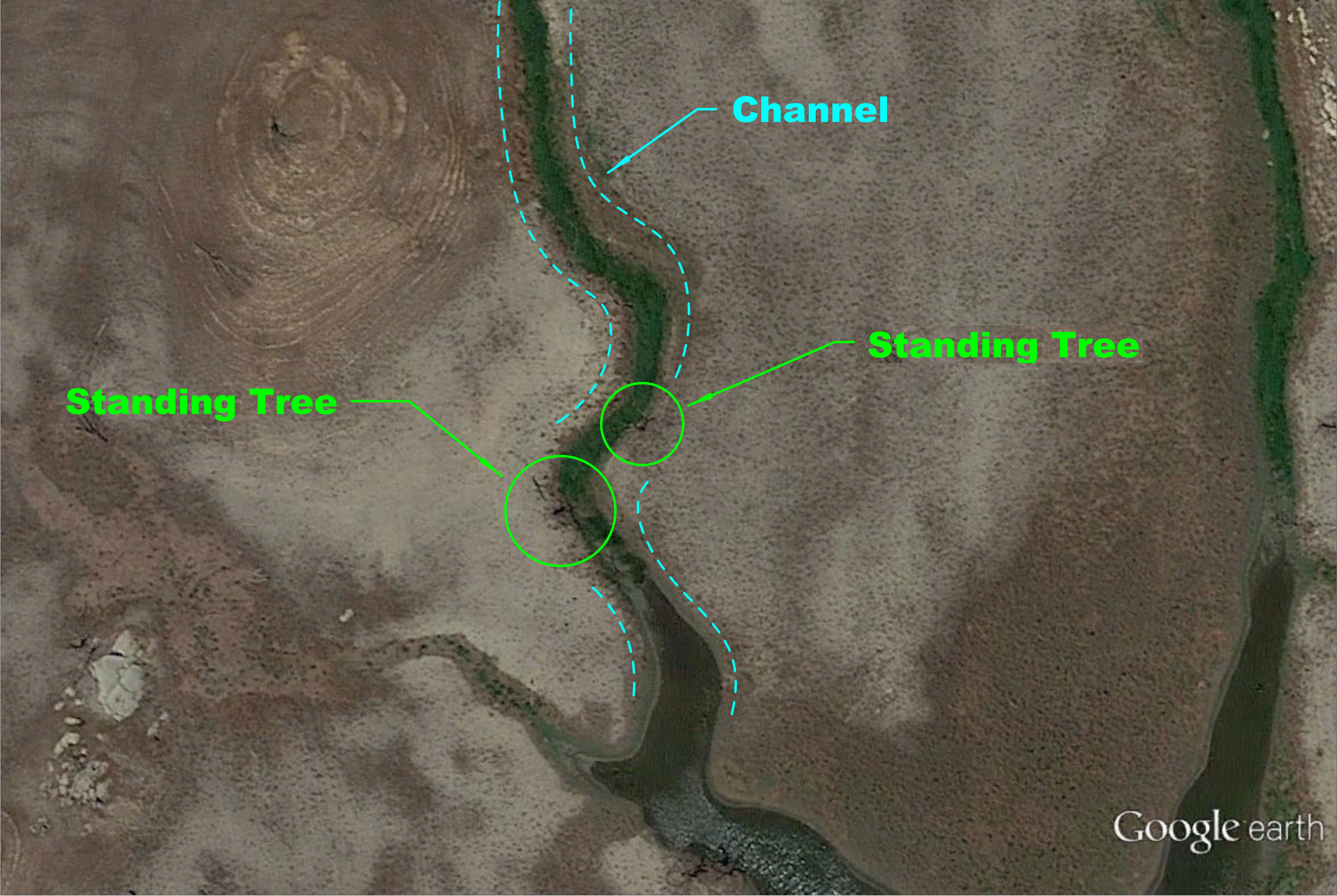
A location with isolated cover such as this may draw in fish from the surrounding area. Depending on the water level, they can suspend just above the trees, inside the channel itself or relating to it along the channel edge. Target something similare and you’ll increase your chances of finding them.
RIVER ARM
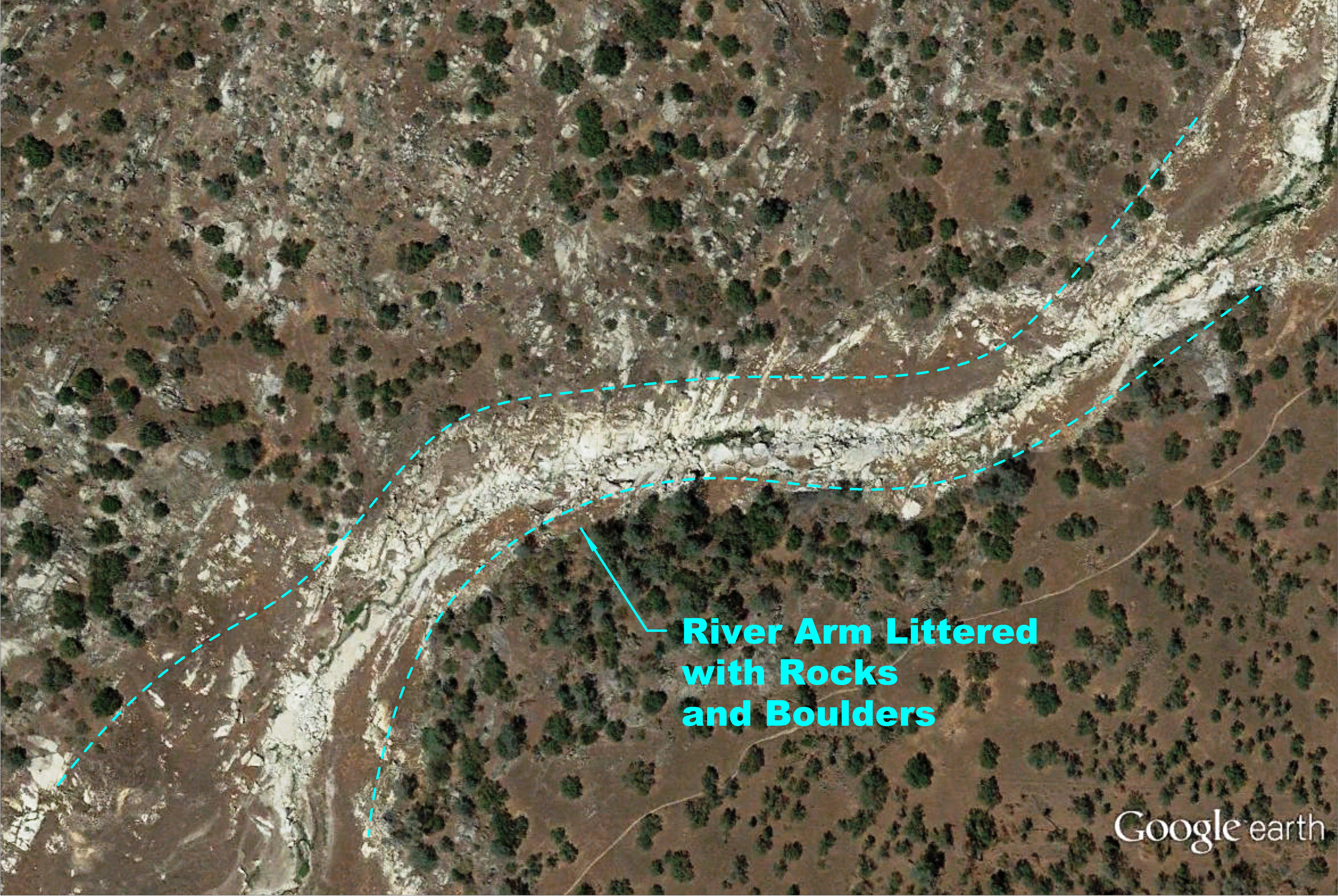
Most lakes or reservoirs have a river that feeds into the estuary. The river water is usually cooler than the lake water in the summer months. When fishing these locations, you want to find where the water begins to change in temperature. Areas with just a few degrees difference may concentrate fish to that location. In the summer time, find where the river water meets the lake water. This area will have a change in temperature that will attract bass much like a thermocline does. Running water also attracts fish to this location because it carries food into the lake and it has more oxygen. One thing you want to look for is cover. This lake in particular has giant boulders and rocks that create breaks from the current. Bass will use these areas to ambush prey or hide in. Caution must be used when fishing these locations because these lakes can fluctuate in elevation without warning. You don’t want to become stranded or hit submerged boulders.
Another location to try are bends in the river. These bends create a break in the current and bass will be drawn to these areas. Below is a section where the river creates almost a 90 degree bend. A location such as this would hold fish when there is water flowing into the lake. Bass will use this break in the current as a staging point for ambushing prey.
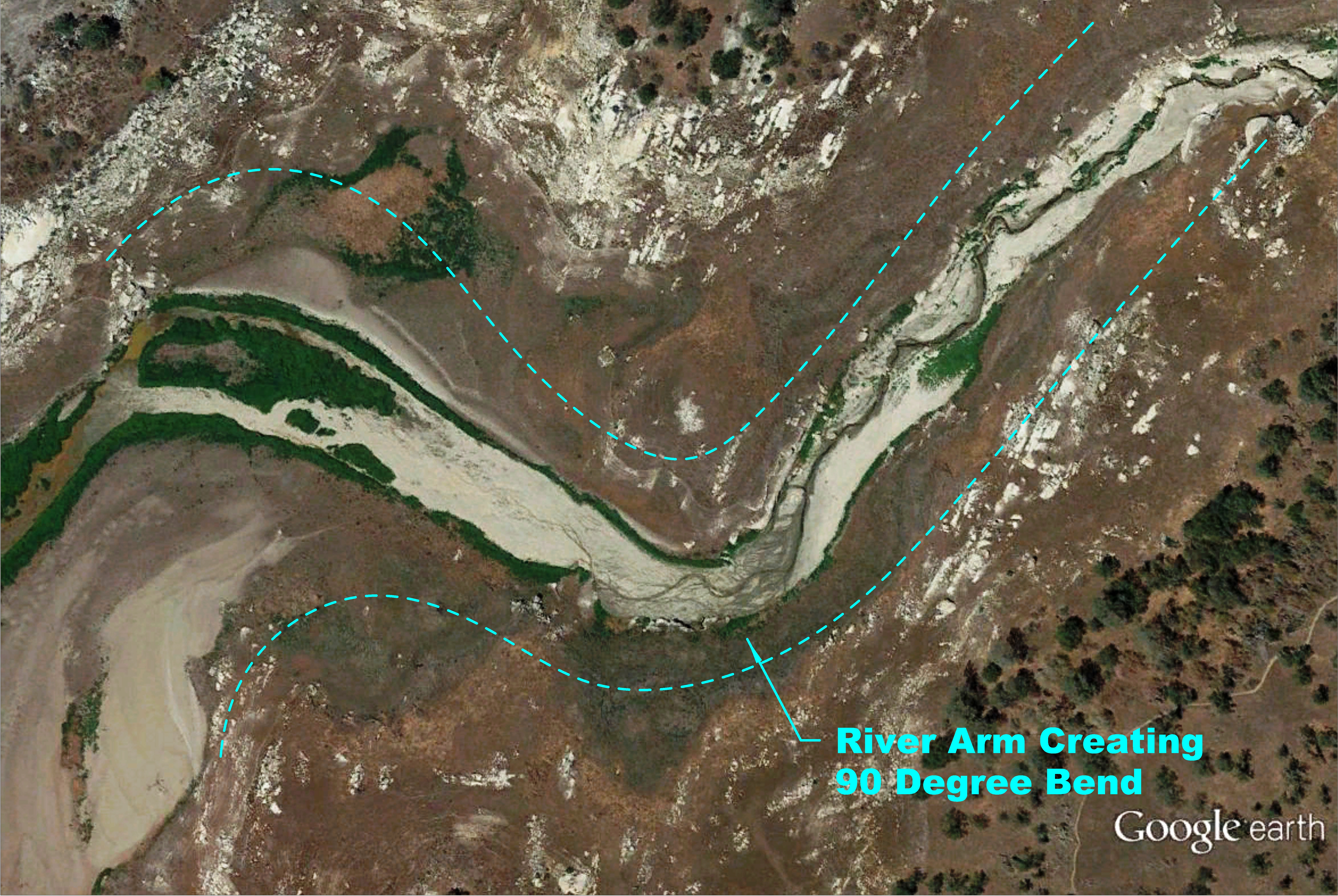
Give this area a try when you’re on the water. It can be one of the least pressured locations on the lake if shore access is limited.
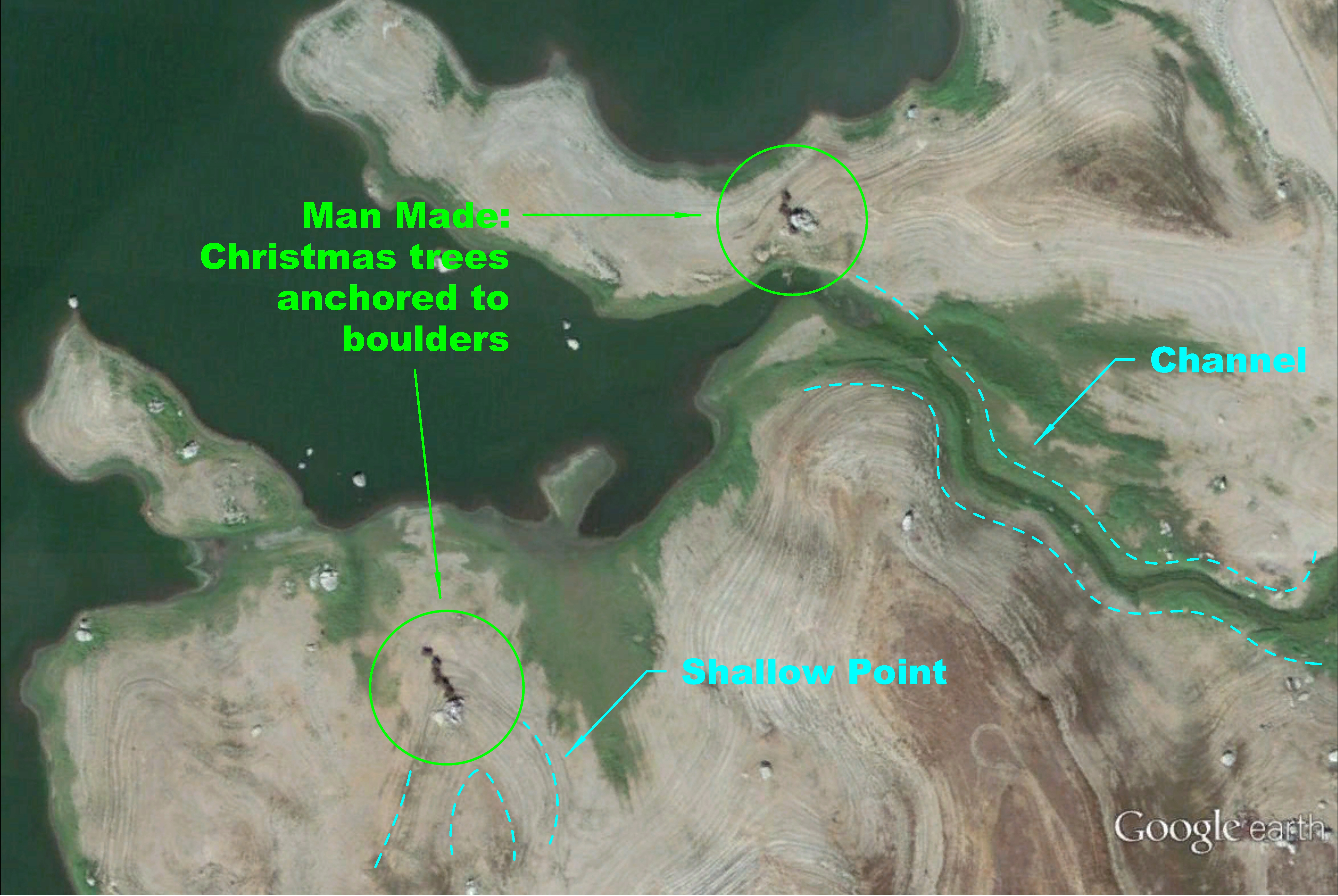
MAN-MADE COVER
Some lakes have programs to restore habitat to the fish population. Management will find potential areas for holding fish and create underwater environments. This lake happens to be one of those lakes. In the winter time, after the holidays, lake management recycles Christmas trees as cover for lake habitat. These habitats can be seen using Google Earth. Check out some of these habitats below.
Christmas trees bundled together.
More Christmas trees bundled together.
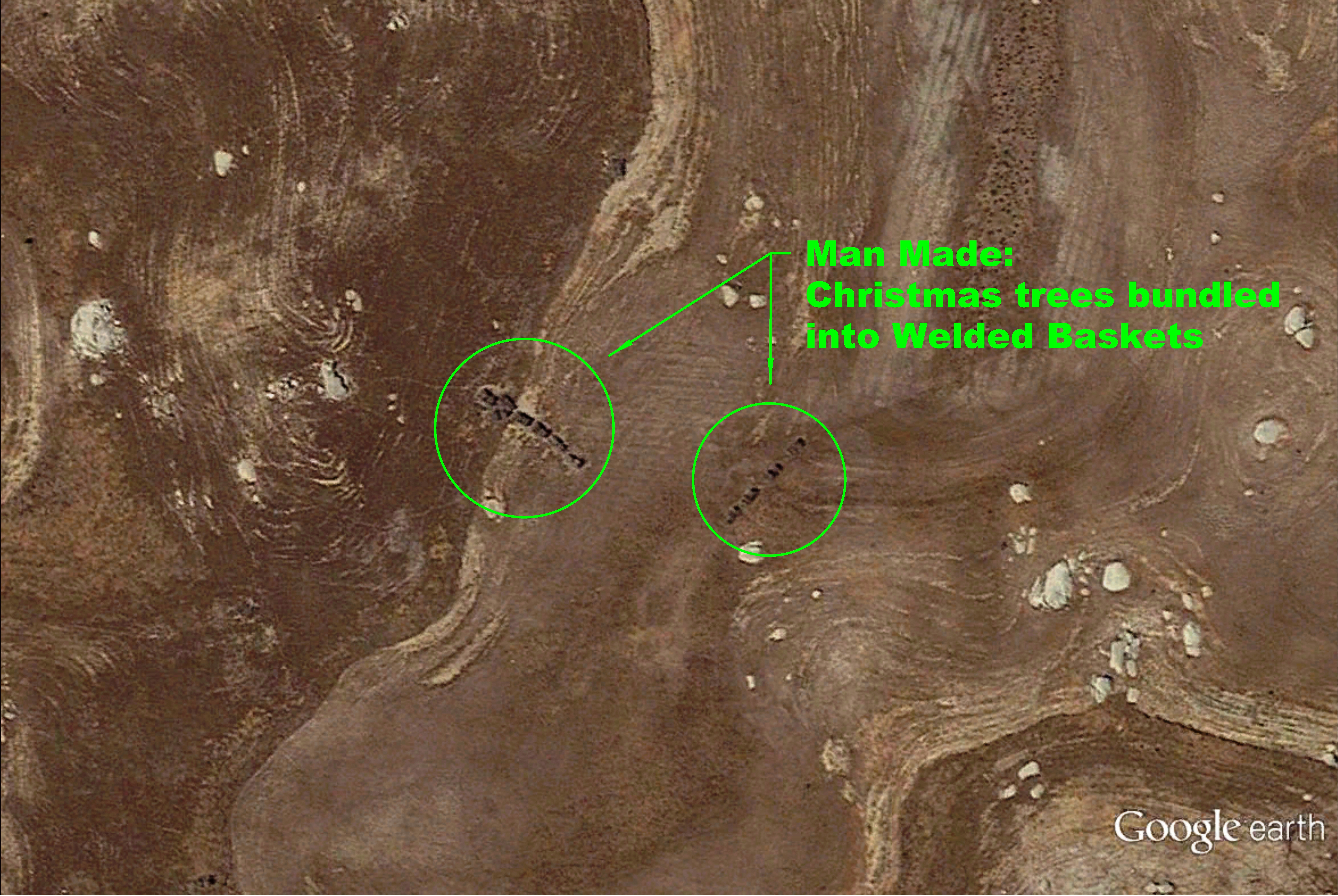
…And more Christmas trees bundled together.
You get the idea. The type of habitat varies from lake to lake. I know some lakes have wooden cribs that serve as artificial habitats for fish while others use concrete slabs. Fishermen themselves will create underwater habitats to attract more fish to a certain area. You will have to do a little homework and identify the types of artificial habitats that populate your lakes. Sometimes it’s hard to identify these man-made cover. The cover itself may have deteriorated from seasonal changes or the habitats may have been removed. When you visit your lake, you need to confirm with your fish finder or visually if the cover is above water, that what you’re seeing is indeed man-made cover. So take advantage of this drought and make note of where these locations are. It’s only a matter of time before the water level rises again.
I ALMOST FORGOT
So you’re probably wondering how you’re going to find all these great places when you’re out on the lake right? Well, Google Earth has a way to mark locations and provide gps coordinates.
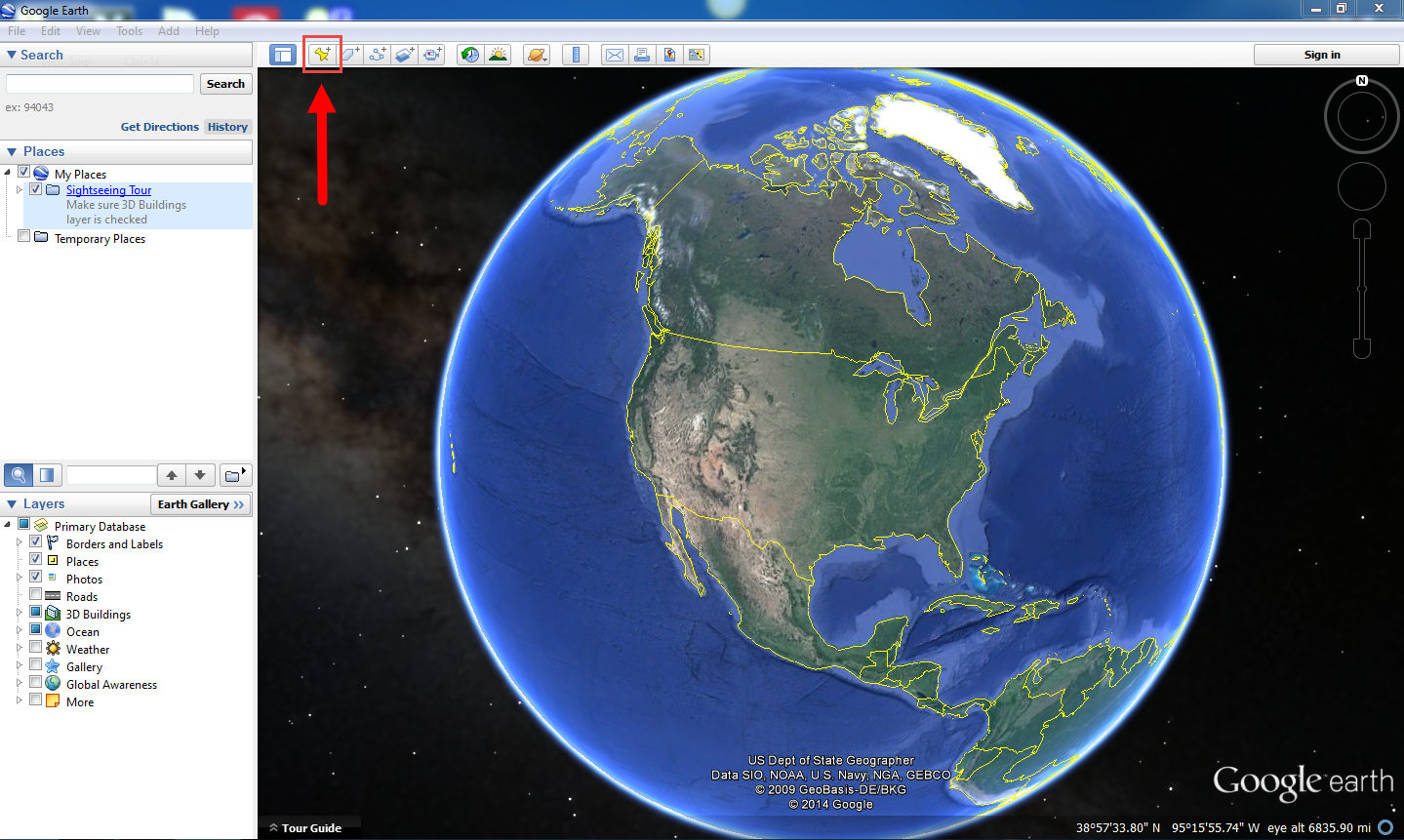
Here’s how you do it. When you locate a potential area, you want to click on the Placemarker icon. The icon is a yellow drop pin located on the top left of the software.
By default it will create a yellow drop pin at the center of your screen. Drag the icon to the fishing location you have just found. You can write down the gps coordinates and name it by the type of structure or cover it is or use the gps coordinates as the title of the name. After finding several locations and having the gps coordinates handy, I like to print out the map to take to the lake, so I can have a reference of the landscape with the placemarkers. Now you’re ready to hit the lake.
Whether you’re heading out to a new lake or one of your favorite ones, the best way to maximize your time on the water is to scout out potential locations where fish will be found. Using Google Earth will help you do just that. Knowing where bass congregate even before you step foot on a lake will save you alot of time searching for them. As I mentioned before, these are just a few locations that may hold fish. Explore your lake and in time you will find new areas that will yield results. Remember that Google Earth is just another tool to identify potential locations. The best way to find productive areas is to go out to the lake and try it out for yourself. Next time you’re thinking about going on a fishing trip, do a little homework and you’ll be spending less time fishing around and more time catching.
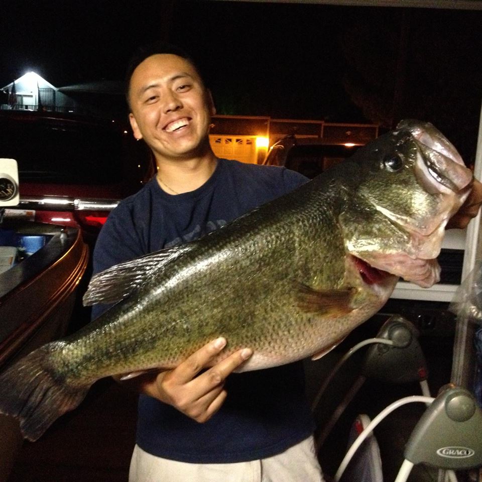
Like what you read? Sign up for the newsletter below and get exclusive content that you cannot find here on the blog, as well as details about how I landed a monster: 14lb Largemouth bass. [mc4wp_form]
NOW IT’S YOUR TURN
Now I want to turn it over to you.
How would you fish these locations? What types of structure/cover do you like to fish at your local lakes?
Leave a comment.
Also, if you have a burning question, leave a comment in the field below.
Great article. Very informative and helpful!
Great article:) I realized once that when you fish perpendicular to the bank, often times the target fish follow the lures to the banks then spook when it sees/senses you. One bank fishing technique I picked up is to cast into a deep end at an angle and on the retrieve end up guiding the lure parallel and close to the banks. That way the target fish and any fish following the lure feels secure ambushing the bait. This is how I catch the majority of my fish anyway 🙂
Oh yeah, that was in regards to fishing banks/ripraps lol
You’re right Ryu. A giant like us can be intimidating to a fish when it sees us. Plus, casting at an angle, you can attract more fish if they are feeding shallow. Thanks for the tip.